ELABORACIÓN DE UN MODELO DIGITAL DE ELEVACIONES DE ALTA RESOLUCIÓN DE LA CUENCA EXPERIMENTAL TORRE RAYÓN, SONORA
DOI:
https://doi.org/10.36790/epistemus.v11i22.41Palabras clave:
GPS, Estación Total, microcuencasResumen
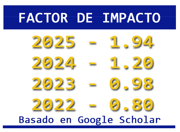
Se desarrolla una procedimiento basado en ArcGIS para la obtención de un modelo digital de elevaciones de alta resolución espacial a partir de puntos de coordenadas (x,y,z) tomados con un sistema de posicionamiento global de doble frecuencia. El modelo se contrasta con valores de altitud tomados con Estación Total, resultando parámetros estadísticos muy similares entre sí y un error cuadrático medio igual a 0.1401, lo que indica la confiabilidad del producto para ser utilizado en estudios avanzados de Hidrología e Hidráulica Fluvial de microcuencas.
Descargas
Citas
Diario Oficial de la Federación. (2014). Norma Técnica para la generación de Información Geográfica en Modelos Digitales de Elevación que se incorpore al Sistema Nacional de Información Estadística y Geográfica. Instituto Nacional de Estadística y Geografía. http://www.dof.gob.mx/nota_detalle.php?codigo=5373796&fecha=02/12/2014
U.S. Geological Survey (1993). Data Users Guide 5 Digital Elevation Models. United States Department of the Interior.
Jenson, S. K. (1991). Applications of hydrologic information automatically extracted from digital elevation models. Hydrological Processes, Vol. 5, 31-44. DOI: https://doi.org/10.1002/hyp.3360050104
Schmidt. F. (2003). Agricultural applications of laserscanner DEMs. Quality Requirements and analysis methods. BEAK Consultants GmbH. ISPRS/EuroSDR Workshop on: 3D reconstruction from airborne laser scanner and InSAR data, Dresden, 8-10 October. http://www.beak.de/beak/en/publications_staff?page=2 Consultado 13/10/2015
Grenzdörffer, G. and Donath, C. (2008). Generation and Analysis of Digital Terrain Models with Parallel Guidance Systems for Precision Agriculture. Proc. 1st International Conference on Machine Control & Guidance. Zurich, Germany. Pp. 141-150.
Mei, C. and Durrieu, S. (2004). Tree crown delineation from digital elevation models and high resolution imagery. Laser-Scanners for Forest and Landscape Assessment. SPRS Archives – Volume XXXVI-8/W2 WG VIII/2. Eds: M. Thies, B. Koch, H. Spiecker, H. Weinacker. 03-06 October. Freiburg, Germany.
Aschoff, T. and Spiecker, H. (2004). Algorithms for the automatic detection of trees in laser scanner data. International archives of Photogrammetry, Remote Sensing and Spatial Information Sciences. Vol. XXXVI -8/W2. http://www.isprs.org/proceedings/XXXVI/8-W2/ASCHOFF.pdf
Zhang, J.X, Chang, K.T. & Wu, J.Q. (2008). Effects of DEM resolution and source on soil erosion modelling: a case study using the WEPP model. International Journal of Geographical Information Science. Vol. 22, Issue 8. DOI: https://doi.org/10.1080/13658810701776817
Abd Aziz, B. L. Steward, A. Kaleita, M. Karkee. (2012). Assessing the effects of DEM uncertainty on erosion rate estimation in an agricultural field. Transactions of the ASABE Vol. 55(3): 785-798 © 2012 American Society of Agricultural and Biological Engineers. DOI: https://doi.org/10.13031/2013.41514
Li, Z. (2014). Watershed modeling using arc hydro based on DEMs: a case study in Jackpine watershed. Environmental Systems Research. https://environmentalsystemsresearch.springeropen.com/articles/10.1186/2193-2697-3-11 Consultado: 13/07/2015 DOI: https://doi.org/10.1186/2193-2697-3-11
Vivoni, E.R., Ivanov, V.Y., Bras, R.L. and Entekhabi, D. (2002). tRIBS User Manual. Department of Civil and Environmental Engineering. Massachusetts Institute of Technology. http://vivoni.asu.edu/tribs/userManual.html Consultado: 15/07/2015
Pryde, J.K., Osorio, J., Wolfe, M.L., Heatwole, C., Benham, B. and Cardenas, A. (2007). Comparison of watershed boundaries derived from SRTM and ASTER digital elevation datasets and from a digitized topographic map. Written for presentation at the 2007 ASABE Annual International Meeting Sponsored by ASABE Minneapolis Convention Center Minneapolis, Minnesota 17 - 20 June. American Society of Agricultural and Biological Engineers.
Instituto Nacional de Estadística y Geografía (sf ). Modelos digitales de elevación MDE –Descripción ¿Qué es un modelo digital de elevación? http://www.inegi.org.mx/geo/contenidos/datosrelieve/continental/queesmde.aspx Consultado: 7/07/2015
Jarvis, A., H.I. Reuter, A. Nelson, E. Guevara. (2008). Hole-filled SRTM for the globe Version 4, available from the CGIAR-CSI SRTM 90 m Database (http://srtm.csi.cgiar.org). Consultado: 21/08/2015
Tachikawa, T., Kaku, M., Iwasaki, A., Gesch, D., Oimoen, M., Zhang, Z., Danielson, J., Krieger, T., Curtis, B., Haase, J., Abrams, M., Crippen, R. and Carabajal, C. (2011). ASTER Global Digital Elevation Model Version 2 – Summary of Validation Results. Compiled by Dave Meyer4 on behalf of the NASA Land Processes Distributed Active Archive Center and the Joint Japan-US ASTER Science Team.
Gillin, C.P., Bailey, S.W., McGuire, K.J. and Prisley, S.P. (2015). Evaluation of Lidar-derived DEMs through Terrain Analysis and Field Comparison. American Society for Photogrammetry and Remote Sensing. Photogrammetric Engineering & Remote Sensing. Vol. 81, No. 5, pp. 387–396. DOI: https://doi.org/10.14358/PERS.81.5.387
Nico, G., Rutigliano, P., Benedetto, C. and Vespe, F. Terrain modelling by kinematical GPS survey. (2005). Natural Hazards and Earth System Sciences. European Geosciences Union. Vol. 5, pp. 293–299. DOI: https://doi.org/10.5194/nhess-5-293-2005
Descargas
Publicado
Cómo citar
Número
Sección
Licencia

Esta obra está bajo una licencia internacional Creative Commons Atribución-NoComercial-SinDerivadas 4.0.
La revista adquiere los derechos patrimoniales de los artículos sólo para difusión sin ningún fin de lucro, sin menoscabo de los propios derechos de autoría.
Los autores son los legítimos titulares de los derechos de propiedad intelectual de sus respectivos artículos, y en tal calidad, al enviar sus textos expresan su deseo de colaborar con la Revista Epistemus, editada semestralmente por la Universidad de Sonora.
Por lo anterior, de manera libre, voluntaria y a título gratuito, una vez aceptado el artículo para su publicación, ceden sus derechos a la Universidad de Sonora para que la Universidad de Sonora edite, publique, distribuya y ponga a disposición a través de intranets, internet o CD dicha obra, sin limitación alguna de forma o tiempo, siempre y cuando sea sin fines de lucro y con la obligación expresa de respetar y mencionar el crédito que corresponde a los autores en cualquier utilización que se haga del mismo.
Queda entendido que esta autorización no es una cesión o transmisión de alguno de sus derechos patrimoniales en favor de la mencionada institución. La UniSon le garantiza el derecho de reproducir la contribución por cualquier medio en el cual usted sea el autor, sujeto a que se otorgue el crédito correspondiente a la publicación original de la contribución en Epistemus.
Salvo indicación contraria, todos los contenidos de la edición electrónica se distribuyen bajo una licencia de uso y Attribution-NonCommercial-ShareAlike 4.0 International (CC BY-NC-SA 4.0) Puede consultar desde aquí la versión informativa y el texto legal de la licencia. Esta circunstancia ha de hacerse constar expresamente de esta forma cuando sea necesario.