Digital Model of the University of Sonora Campus through Photogrammetry with Drones
DOI:
https://doi.org/10.36790/epistemus.v17i34.263Keywords:
Construction management, Aerial photogrammetry, Drone, Digital modelAbstract
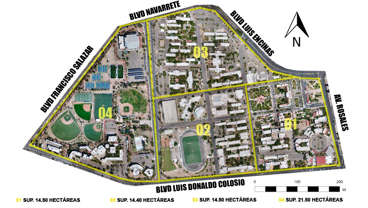
The objective of this study was to provide a perspective of the aerial photogrammetry’s scope to carry out different activities in construction engineering in general. Additionally, to determine if a commercial drone is able to perform tasks that facilitate work in some administrative management processes at the University of Sonora for purposes of logistics, planning, maintenance, and work progress records inside the campus. Comparisons were made between physical field measurements in a traditional way, and digital measurements in the 3D point cloud model generated by the software. From this comparison, an average value of 3.7 millimeters of variation per linear meter was obtained.
Downloads
References
McKinsey Global Institute, "Reinventing construction: a route to higher productivity," McKinsey & Company, 2017.
V. Charlesraj and N. Rakshith, "Stakeholder perspectives on the adoption of drones in construction projects," Kitakyushu, Japan, 2020. Doi: 10.22260/ISARC2020/0168. DOI: https://doi.org/10.22260/ISARC2020/0168
C. Loveless, "Drones in Construction," Available at SSRN, pp. 1-30, 2017. DOI: https://doi.org/10.2139/ssrn.3111338
T. Umar, "Applications of drones for safety inspection in the Gulf Cooperation Council construction," Engineering, Construction and Architectural Management, 2020. Doi: 10.1108/ECAM-05-2020-0369. DOI: https://doi.org/10.1108/ECAM-05-2020-0369
D. Arba, "Using Unmanned Aerial Vehicles for Automated BIM-based Construction Progress & Reporting," PM World Jurnal, vol. 9, no. 8, pp. 1-15, 2020.
K. Korkmaz and S. Mohammed, "Evaluating the Use of Drones in the Area of Transportation / Construction," Journal of Architectural Environment & Structural Engineering Research, vol. 03, no. 01, pp. 1-4, 2020. Doi: 10.30564/jaeser.v3i1.1787. DOI: https://doi.org/10.30564/jaeser.v3i1.1787
H. Golizadeh, M. RezaHosseini, D. Edwards, S. Abrishami, N. Taghavi and S. Banihashemi, "Barriers to adoption of RAPs on construction projects: a task-technology fit perspective" Construction Innovation, vol. 19, no. 2, pp. 149-169, 2019. Doi: 10.1108/CI-09-2018-0074. DOI: https://doi.org/10.1108/CI-09-2018-0074
F. Canhete and R. Machado, "The use of drones in urban construction: literature review," International Jounal of Development Research, vol. 10, no. 02, pp. 44388-44396, 2021. Doi: 10.37118/ijdr.20946.02.2021.
F. Mesas and A. García-Ferrer, "Aplicaciones Urbaníticas," in Los drones y sus aplicaciones a la ingeniería civil, Madrid, 2015, pp. 211-219.
M. Oñate, "Tipología de aeronaves pilotadas por control remoto," in Los drones y sus aplicaciones a la ingeniería civil, Madrid, 2015, pp. 49-57.
Y. Li and C. Liu, "Applications of multirotor drone technologies in construction mangement," International Journal of Construction Management, vol. 19, no. 5, pp. 401-412, 2018. Doi: 10.1080/15623599.2018.1452101 DOI: https://doi.org/10.1080/15623599.2018.1452101
D. Saez and A. Beltrán, "Aplicaciones cartográficas," in Los drones y sus aplicaciones a la ingeniería civil, Madrid, 2015, pp. 67-76.
Í. Campo, "Aplicaciones en el control de obras y evaluación de impactos," in Los drones y sus aplicaciones a la ingeniería civil, Madrid, 2015, pp. 149-160.
Y. Jiang and Y. Bai, "Determination of construction site elevations using drone technology," in Construction Research Congress, Tempe, Arizona, 2020. Doi: 10.1061/9780784482865.032 DOI: https://doi.org/10.1061/9780784482865.032
E. Ciampa, L. De Vito and M. Pecce, "Practical issues on the use of drones for construction inspections," Journal of Physics: Conference Series, pp. 1-11, 2019. Doi:10.1088/1742-6596/1249/1/012016 DOI: https://doi.org/10.1088/1742-6596/1249/1/012016
M. Mongelli, d. C. G. I. Roselli, M. Malena, A. Nacuzi and G. de Felice, "3D Photogrammetric Reconstruction by Drone Scanning for FE Analysis and Crack Pattern Mapping of the “Bridge of the Towers”, Spoleto," Key Engineering Materials, vol. 747, pp. 423-430, 2017. Doi: 10.4028/www.scientific.net/KEM.747.423. DOI: https://doi.org/10.4028/www.scientific.net/KEM.747.423
E. Tacuri, L. Lupercio, G. Lupercio and M. López, "Uso de imágenes de RPAS para generación de topografía a detalle," Revista Geoespacial, vol. 14, no. 1, pp. 32-42, 2017. Doi: 10.24133/geoespacial.v14i1.1594.
P. Aparicio, F. Espinoza-Figueroa, M. d. C. Aguirre, P. Mejía and C. Matovelle, "Fotogrametría digital para el levantamiento 3D del sitio arqueológico de Todos Santos, Cuenca (Ecuador)," Estoa, vol. 7, no. 13, pp. 25-35, 2018. Doi: 10.18537/est.v007.n013.a02. DOI: https://doi.org/10.18537/est.v007.n013.a02
R. Melo and D. Costa, "Reducing the gap between work as done and work as imagined on construction safety supported by UAS," Kalmar, Sweden, 2019. Doi: 10.15626/rea8.02. DOI: https://doi.org/10.15626/rea8.02
Secretaría de Comunicaciones y Transportes, Norma Oficial Mexicana NOM-107-SCT3-2019, Diario Oficial de la Federación, 2019.
Downloads
Published
How to Cite
Issue
Section
License
Copyright (c) 2023 EPISTEMUS

This work is licensed under a Creative Commons Attribution-NonCommercial-ShareAlike 4.0 International License.
The magazine acquires the patrimonial rights of the articles only for diffusion without any purpose of profit, without diminishing the own rights of authorship.
The authors are the legitimate owners of the intellectual property rights of their respective articles, and in such quality, by sending their texts they express their desire to collaborate with the Epistemus Magazine, published biannually by the University of Sonora.
Therefore, freely, voluntarily and free of charge, once accepted the article for publication, they give their rights to the University of Sonora for the University of Sonora to edit, publish, distribute and make available through intranets, Internet or CD said work, without any limitation of form or time, as long as it is non-profit and with the express obligation to respect and mention the credit that corresponds to the authors in any use that is made of it.
It is understood that this authorization is not an assignment or transmission of any of your economic rights in favor of the said institution. The University of Sonora guarantees the right to reproduce the contribution by any means in which you are the author, subject to the credit being granted corresponding to the original publication of the contribution in Epistemus.
Unless otherwise indicated, all the contents of the electronic edition are distributed under a license for use and Creative Commons — Attribution-NonCommercial-ShareAlike 4.0 International — (CC BY-NC-SA 4.0) You can consult here the informative version and the legal text of the license. This circumstance must be expressly stated in this way when necessary.
The names and email addresses entered in this journal will be used exclusively for the purposes established in it and will not be provided to third parties or for their use for other purposes.